


minnesota.cbslocal.com
Minnesota Weather: Historic December Storm Brings 2 Possible Tornadoes
A rare winter thunderstorm possibly whipped up two December tornadoes in Minnesota Wednesday night -- an unprecedented event in recorded state history.
Local
MINNEAPOLIS (WCCO) — A rare winter thunderstorm possibly whipped up two December tornadoes in Minnesota Wednesday night — an unprecedented event in recorded state history.
The National Weather Service said it will send one team to Freeborn and possibly Faribault County in Minnesota on Thursday to determine “whether damage was caused by a tornado or straight line winds” in the Hartland area. Damage will also be assessed in Eau Claire County in Wisconsin.
If it’s determined that there was evidence of a tornado, it will be assigned a strength rating. Preliminary results are expected by late afternoon.
Our next challenge could be rain-soaked roads that ice over just in time for the Thursday morning commute. Anne Meyer with the Minnesota Department of Transportation says crews will have to wait before treating the roads.
“One big challenge with this particular storm is we can’t pre-treat when it’s raining. That material will wash away,” Meyer said.
After the rain, MnDOT will move in before things freeze over by early Thursday morning.
“Here in the Twin Cities metro, crews are going to staff up around midnight,” Meyer said. “We could also see some debris on roadways. That commute in the morning could be challenging.”
As of late Wednesday night, Xcel Energy said more that 7,000 customers were without power, with 5,800 of those in southeastern part of the state.
Strong winds continued into Thursday, with gusts around 40 mph across the state. A Wind Warning will be in effect through 6 a.m. for much of Minnesota, and a Winter Storm Warning will be in effect for much of northern Minnesota.
About 1-3 inches will fall north of Interstate 94, and the Twin Cities may get a quick dusting, too. Snow showers should wrap up by the afternoon.
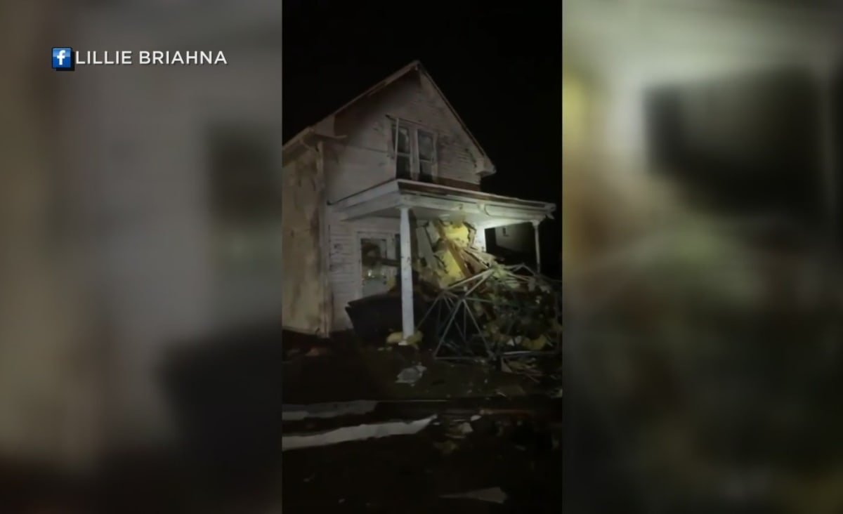
A possible tornado struck northwest of Albert Lea in Hartland just after 7 p.m., while another unconfirmed one hit just southwest of Wabasha. There are reports of heavy damage to a bank and several homes in Hartland, where winds topped 85 mph. There were no reported injuries.
WCCO spoke with a viewer named Lillie who was in Hartland as the storm passed through. She says her family went into the basement, bringing their dog and cat. She says it was very quiet, and then her mom described the roar of the wind as sounding like a train. When she felt like the danger passed, they walked about a block from their home to a main street and saw some of the damage. Lillie says they are without power Wednesday night.
The Twin Cities was under a Tornado Watch for several hours, which the National Weather Service canceled around 10 p.m.
WCCO Meteorologist Chris Shaffer says the rest of Minnesota dealt primarily with wind issues, with gusts in excess of 85 mph. Most reported damage just involved trees.
It got to 54 degrees in Twin Cities late Wednesday night, but it was below freezing in the Fargo/Moorhead area.
Temperatures will continue dropping through Thursday. The high in the Twin Cities will be a deceptive 30, since they already hit that in the morning hours and it will only get colder throughout the day.
More snow is possible on Friday and Saturday.