


www.local10.com
Hurricane Lee mounts a comeback, Bermuda on alert this week
It’s been a soap opera for Hurricane Lee. After rapidly strengthening to a Category 5 Thursday night at an historic pace – a blistering 85 mph increase in maximum winds in 24 hours (tied for the third fastest-strengthening Atlantic hurricane) – Lee hit a wall over the weekend, rapidly weakening back down to a Category 2 by Saturday evening.
Local
It’s been a soap opera for Hurricane Lee. After rapidly strengthening to a Category 5 Thursday night at an historic pace – a blistering 85 mph increase in maximum winds in 24 hours (tied for the third fastest-strengthening Atlantic hurricane) – Lee hit a wall over the weekend, rapidly weakening back down to a Category 2 by Saturday evening.
After undergoing a quick eyewall replacement cycle early Sunday, Lee found its second wind and by Sunday afternoon had regained major (Category 3) status.
Thus far, the powerful hurricane has managed to avoid any direct entanglements with land, but as it slows and bends northward this week – sparing Florida and the Bahamas – the focus will turn to Bermuda for late week and potential impacts to the far northeast U.S. and the Canadian Maritimes by late weekend.
Will Lee reclaim its Category 5 crown?
Category 5 hurricanes are a rare breed. Only about 4% of all hurricanes and 2% of all named storms ever see winds exceeding 156 mph, the Category 5 threshold. They’re the kind of hurricanes we might expect to see on average every 4 or 5 years. Only 7 hurricane seasons of the 172 for which records exist have ever observed more than one Category 5 hurricane.
Needless to say, it takes an ideal environment to cook up a Category 5 hurricane. Wind shear has been persistent since Friday, but the shear has since subsided and conditions today into tomorrow will support a restrengthening, although it’s unlikely Lee will once again reach Category 5 status.
Its window of opportunity today may additionally be thwarted by what appears to be another ongoing eyewall replacement cycle. Although this may broaden Lee’s expansive wind field, it would also temporarily halt strengthening.
By mid-week, it’ll be moving over a cold wake zone created by Hurricanes Franklin and Idalia over the past few weeks.
Though waters in the deep Atlantic remain at record levels, waters farther north are the rare cool exception thanks to upwelling from the recent spate of big Atlantic hurricanes.
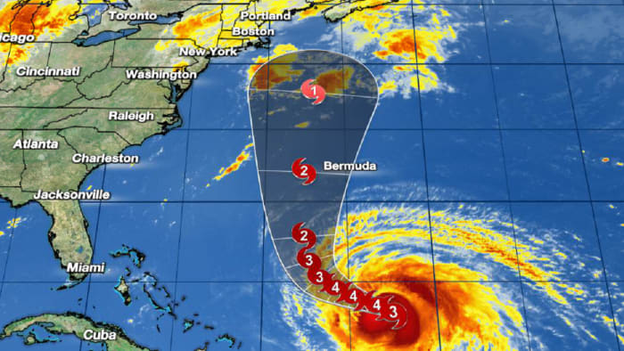
Bermuda in the cone
Lee should make its closest approach to Bermuda sometime late Thursday or Friday. Right now, the center is forecast to pass some 150 miles or so west of Bermuda. This is, however, near the average NHC forecast error 4-5 days out, so residents and visitors to Bermuda should monitor forecast changes carefully in the days ahead.
Regardless, Lee’s growing wind field may be problematic for Bermuda even if the center passes well west later this week.
Is Lee a threat to the Northeast U.S.?
First things first – Lee’s wind field has already begun to expand and will continue to do so this week. This is a big issue for long-period swell reaching the U.S. shoreline, expected to produce battering waves and life-threatening rip currents along much of the U.S. East Coast all week. The coastal concerns from this swell will increase as the week progresses, especially from the mid-Atlantic northward. This week will be a good week to stay out of an angry Atlantic.