


www.local10.com
Idalia forecast to threaten Florida’s Gulf Coast as major hurricane; hurricane, storm surge warnings expected today
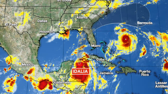
Tropical Storm Idalia, which formed late morning Sunday, is forecast to steadily strengthen into a hurricane today and intensify into a major (Category 3 or stronger) hurricane over the eastern Gulf of Mexico as it accelerates toward Florida’s Gulf Coast on Tuesday and Wednesday.
Local
Tropical Storm Idalia, which formed late morning Sunday, is forecast to steadily strengthen into a hurricane today and intensify into a major (Category 3 or stronger) hurricane over the eastern Gulf of Mexico as it accelerates toward Florida’s Gulf Coast on Tuesday and Wednesday.
Once Idalia moves, it will do so quickly and conditions will go downhill fast tomorrow for affected areas in Florida. Residents from north of Fort Myers in southwest Florida to just west of Apalachicola along the western edge of Florida’s sweeping Big Bend should listen carefully to local officials, as evacuation orders are expected for many places beginning today.
Since tropical storm conditions will arrive in Florida tomorrow, those under a Hurricane Watch should take today to button down preparations, including shutter installation, securing lawn and outdoor items, and moving boats to safer locations.
Because Idalia will be moving quickly, the forecast cone will get stretched and doesn’t reflect the area of possible impact.
Hurricane winds, flooding rains, and life-threatening storm surge often extend outside of the cone so at this stage don’t focus on the cone. If you’re under a Hurricane or Storm Surge Watch or Warning, you’re at risk for potentially life-threatening impacts whether or not you’re in the cone.
Idalia has been meandering over the warm waters of the western Caribbean just east of Mexico’s Yucatán Peninsula all weekend, but is beginning to quicken its stride northward and is expected to accelerate toward Florida’s Gulf Coast on Tuesday.
While steady strengthening is forecast today, the storm is currently being held back by some modest northerly wind shear. As upper winds realign tomorrow, however, a faster rate of strengthening is expected and Idalia is forecast to be a major (Category 3 or stronger) hurricane as it approaches Florida on Wednesday.
Major flood threat at the coast and inland
Nearly 9 in 10 direct deaths in hurricanes comes from the water. Just last year, over 40 people drowned in Hurricane Ian’s catastrophic storm surge. A study released earlier this month by the National Hurricane Center found that over the past decade some 250 deaths have occurred from freshwater (rainfall-related) flooding in the U.S. compared to only around 50 wind-related hurricane deaths. Water has consistently been the biggest killer in hurricanes.
Idalia is forecast to bring a tremendous amount of water as it moves ashore this week, first along the coast in the form of destructive and life-threatening storm surge flooding. The National Hurricane Center is currently forecasting up to 11 feet of storm surge flooding into Florida’s Big Bend and up to 7 feet south to Tampa Bay.
For recent reference, Ian’s storm surge reached 10-15 feet at Fort Myers Beach when it came ashore last September. The Big Bend and west coast of Florida are particularly susceptible to storm surge due to the adjacent wide, shallow ocean floor and concave coastline.
Idalia will also bring a flood threat inland across parts of the southeastern states through Thursday along the I-95 corridor from northeast Florida to the coastal plains of North Carolina. The National Weather Service is forecasting a moderate risk of flash flooding for these areas beginning Wednesday morning.
The bottom line
Idalia is shaping up to be a potentially devastating and historic hurricane hit for Florida’s Gulf Coast. Don’t let the slow movement this weekend fool you. The hurricane will be ashore in Florida by as early as Wednesday, with tropical storm conditions (winds of 39-73 mph) moving in tomorrow. If you’re under a Hurricane or Storm Surge Watch or Warning, heed the advice of local officials and use today to finalize any last minute hurricane preparations.
Franklin, now a Category 4 hurricane, to pass west of Bermuda this week
Franklin continued to strengthen this morning over the open waters between the Bahamas and Bermuda, with winds now topping 130 mph, making it a Category 4 hurricane and the strongest hurricane so far of the 2023 Atlantic hurricane season.
Though forecast guidance waffled yesterday to suggest a more direct threat to Bermuda, it appears the center will pass safely west, though tropical storm conditions could still be felt in the archipelago as the hurricane makes its closest approach late Tuesday into early Wednesday.
Elsewhere in the Atlantic
A tropical wave is set to roll off Africa over the next day or so and may slowly develop. For now, it’s expected to curl into the open Atlantic and stay out to sea.