


www.cnn.com
Dangerous ice storm, heavy snowfall, potential travel woes and power outages expected in the Southeast
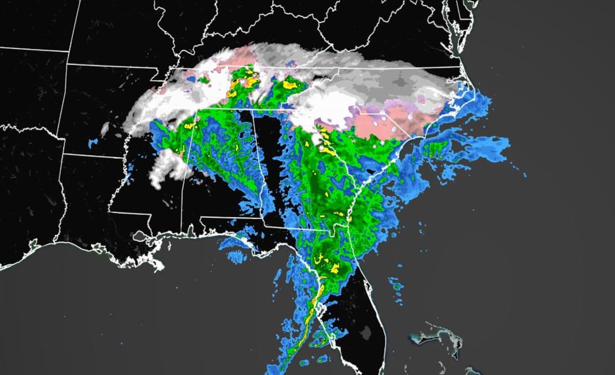
A vicious winter storm will slice through parts of the Southeast Sunday, dropping freezing rain, ice and snow on cities and states that don't normally see much of the white stuff.
Local
(CNN)A vicious winter storm will slice through parts of the Southeast Sunday, dropping freezing rain, ice and snow on cities and states that don't normally see much of the white stuff.
As many as 80 million people are under winter weather alerts from that region to the Northeast, CNN meteorologist Derek Van Dam said.
"I am particularly concerned for the impending ice storm that will impact the interior of South and North Carolina. Following a round of heavy snow, up to 3/4 of an inch of ice could accumulate," Van Dam said.
"This will certainly bring power outages in the area as winds gust over 40 mph," he added.
Greenville, South Carolina, and Charlotte and Raleigh in North Carolina are under winter storm warnings, forecasters said. As much as a foot of snow could fall near the edge of the Blue Ridge escarpment in Greenville and as much as 20 inches of snow could accumulate above 4,000 feet of elevation in that area. A tenth of an inch of ice is also possible.
The National Weather Service has issued an ice storm warning for portions of South Carolina, in effect through early Monday, with temperatures likely to remain sub-freezing until the start of next week.
"Significant amounts of ice accumulations will make travel dangerous or impossible. Travel is strongly discouraged," according to the NWS office in Greenville.
Bookmark this site to check if snow is forecast for your region
Charlotte could get up to a foot of snow in the foothills, and possibly as much as a half-inch of ice. Raleigh is expected to get up to 2 inches of snow and maybe a quarter-inch of ice, forecasters said.
The NWS is warning that ice accumulations will become very dangerous along and east of I-85 including Spartanburg, South Carolina, all the way up to Salisbury, North Carolina. This includes the entire metro Charlotte area. "The highest snowfall totals are expected along the spine of the Appalachians as well as across the lower Great Lakes," the National Weather Service said early Sunday.