


apnews.com
Flying drones and chasing data, Indigenous women in Guyana join fight against climate change
A small group of Indigenous women in northern Guyana are flying drones and chasing data to help understand climate change and stop the worst of its impacts. The young Amerindian women are scanning mangrove forests to watch for illegal cutting. They also hope to start collecting soil samples and mangrove litter soon to measure how much carbon is being sequestered in remote coastal ecosystems that have been out of reach for scientists. That work could nudge the government to create policies and programs to protect critical areas. And few places are as vulnerable to climate change as Guyana, where most of the population lives below sea level on a coastline that relies on a nearly 300-mile seawall built centuries ago.
International
RUBY VILLAGE, Guyana (AP) — A small group of Indigenous women in northern Guyana are the latest weapon in the fight against climate change in this South American country where 90% of the population lives below sea level.
Armed with drones, the women are scanning mangrove forests for illegal cutting and expect to soon start collecting soil samples and mangrove litter to measure the carbon held in remote coastal ecosystems that have long been out of reach for scientists. Such data could nudge the government to create policies and programs to protect critical areas.
“We are merging traditional knowledge and scientific research to get all this information that we need but never had before and couldn’t afford to get,” said Annette Arjoon-Martins, head of Guyana’s Marine Conservation Society.
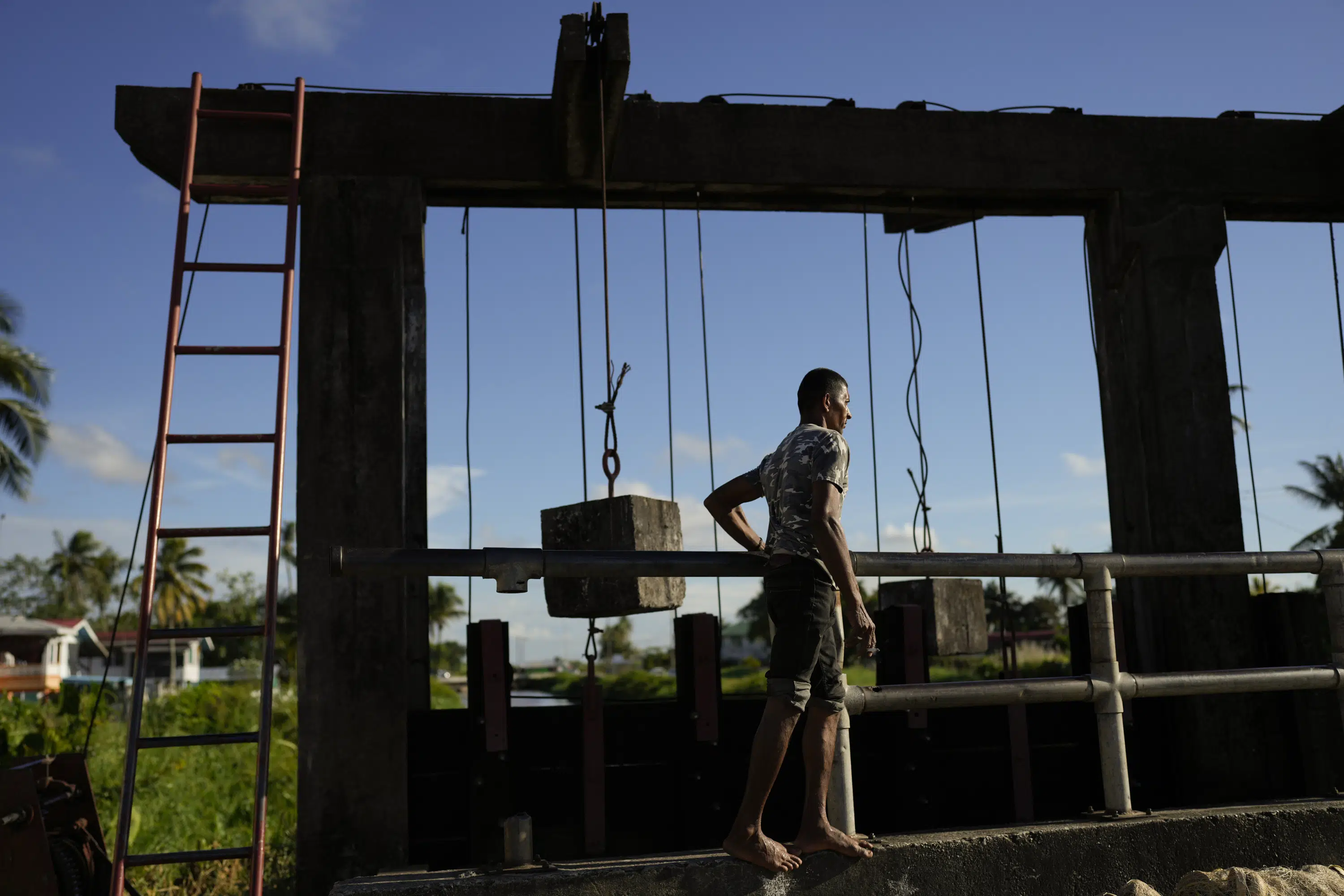
The women’s work is considered key for Guyana, a small nation about the size of Britain that has a 285-mile-long (459 kilometers) coastline whose coastal plains lie an average of 6 feet (2 meters) below sea level. The coastline depends on a centuries-old sea defense system created by the Dutch during the colonial era. It includes a 280-mile (450-kilometer) seawall and relies on dozens of workers who set alarms night and day to manually open and close sluice gates known as “kokers” that prevent the Atlantic Ocean from flooding Guyana.
By the mid-1990s, the Inter-American Development Bank already was advising Guyana to relocate communities inland since most of its 791,000 people live along the coast, and much of its economic activity and agriculture are based there. But people have been reluctant to leave.
A World Bank report has cautioned that “the impact of rising sea levels and intensified storm surges in Guyana would be among the greatest in the world, exposing 100% of the country’s coastal agriculture and 66.4% of coastal urban areas to flooding and coastal erosion.”
The community of Almond Beach in northern Guyana was forced to relocate several years ago after the ocean swallowed line after line of palm trees and began to lap at the school and other infrastructure, Arjoon-Martins said. Some 280 people once lived there; barely three dozen remain after a swath of land slipped underwater, she said.
Environmentalists say the work of the young Amerindian women will help them understand the challenges Guyana faces and what it can do to fight climate change as it prepares to become one of the world’s largest offshore oil producers.
By the end of the year, the women hope to start collecting data on how much carbon the coastal ecosystems around their villages are storing.
“We’ve never done a blue carbon baseline in Guyana before,” Arjoon-Martins said. “We want to quantify how much carbon this entire landscape stores, not just the trees.”
Knowing the baseline would help boost protection of that area and possibly lead to similar programs like the low-carbon development strategy launched in 2009 to protect Guyana’s forests, which cover nearly 90% of the country. That year, Norway signed a deal to provide $250 million in funding to ensure that Guyana’s 18 million hectares of forest remain intact. In December, Hess Corporation agreed to buy $750 million worth of carbon credits to protect those forests.
The indigenous women are gathering data and images at a crucial moment: Guyana is in the midst of an oil boom expected to make it the world’s fourth-largest offshore oil producer, raising concerns about potential oil spills and the oil’s contribution to the same climate change that threatens its existence.
An ExxonMobil consortium that includes Hess Corporation and China’s CNOOC is producing some 380,000 barrels of oil a day, a number that is expected to jump to 1.2 million by 2027.
Guyana Vice President Bharrat Jagdeo, who helped launch the 2009 low-carbon development strategy when he was president and has long led the fight to protect the country’s forests and mangroves, dismissed environmental concerns tied to oil production and greenhouse gas emissions. He called the oil production a “little operation” and criticism from environmentalists as “nonsense.”
But environmentalists say they are greatly concerned about potential threats including oil spills.
Earlier this month, a court in Guyana ordered ExxonMobil to set aside sufficient funds in the case of such an event and threatened to suspend the country’s Environmental Protection Agency if the oil company does not take out unlimited liability insurance within 30 days. In its ruling, the court accused the EPA of being “derelict, pliant and submissive” in its alleged omissions. The agency appealed and lost.
ExxonMobil has filed its own appeal, saying the court had “failed to recognize” that it and its partners have the ability to meet their financial obligations and that it already has insurance in place.
The concerns add to existing ones including the unlawful cutting of mangroves, fires, illegal construction and fuel pollution in rivers that the Amerindian women are scanning in the Barima-Mora Passage in northern Guyana.
Every three months, they fly their drones to inspect an area of some 47,000 hectares (116,000 acres) that includes 14,000 hectares (35,000 acres) of mangroves — Guyana’s largest mangrove forest ecosystem. Mangroves act as a natural buffer against rising sea levels and help protect from coastal erosion. The soil they grow in also absorbs large quantities of carbon that would otherwise contribute to a warming Earth.
“It is me giving back to the environment,” said Shakira Yipsam, 19, who leads the drone team and lives in the Amerindian village of Aruka Mouth, located near a river that drains into the Atlantic.
The women’s mentor is 22-year-old Sarah Singh, who majored in marine biology and now works with the conservation society. She trained the women for up to eight months as part of a program that pays them roughly $700 a month. The program targets young women in Amerindian villages because “they’re usually the ones who leave school and start a family at an early age and don’t really have employment opportunities,” Singh said.
Their work builds on previous conservation efforts that included the replanting of seven miles’ (11 kilometers’) worth of mangroves across Guyana as part of a partnership with the European Union about a decade ago. That replanting led to another nearly 1,000 hectares (2,400 acres) of mangroves that regenerated naturally, Arjoon-Martins said.
Protecting and planting natural buffers like mangroves are key since rising sea levels and coastal flooding are a big concern in Guyana, whose name means “land of many waters.” Sea level rise here has been in line with the global average of 4 millimeters a year over the past 30 years, according to Steve Nerem, a sea level rise expert at the University of Colorado.
The narrow coastal strip where most people live and grow crops represents only 5% of Guyana’s territory and is intersected by three large rivers, according to a study published by professors at the University of Western Ontario.
The area has been affected by rainfall patterns that have changed and hit Guyana’s rice industry particularly hard, said Ulric Trotz, former deputy director at Belize’s Caribbean Community Climate Change Center.
“It’s leading to flooding, landslides and destruction of crops,” he said.
Major flooding events that Trotz attributes to climate change have been reported across Guyana in recent years, including in Mahaicony, southeast of the capital of Georgetown, where saltwater inundated swaths of farmland nearly two years ago, rendering it useless.
The magnitude of the floods, coupled with high tides, overwhelm the sluice gates and colonial-era seawall, but Arjune Lilmohan, 32, said he is not giving up the fight. Like dozens of other workers, he said he sets his alarm in the middle of the night to open and close the koker in his community because it’s his responsibility to protect Guyana from the Atlantic Ocean.
“If you sleep on the job, you get flood,” he said.