


www.yahoo.com
California's fires are so intense, some make their own thunderstorms. NASA calls the formations the 'fire-breathing dragon of clouds.'
The pyrocumulonimbus cloud can generate smoky rain, lightning, and in some cases, tornadoes (sometimes called firenadoes).
Local
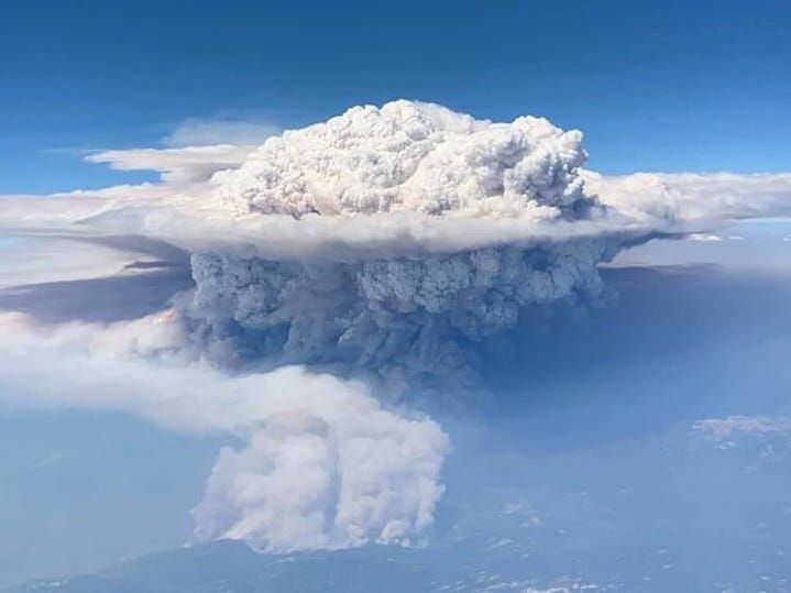
As Thalia Dockery's flight to Las Vegas passed over central California on September 5, the passengers caught an ominous view out their windows: A huge, grey cloud mushroomed thousands of feet into the sky.
It looked like the product of an atomic explosion or volcanic eruption. But what they'd spotted was a pyrocumulonimbus cloud — an enormous plume of hot, smoky air that had risen from a wildfire, then turned into a thundercloud in Earth's atmosphere.
"I just so happened to look out my window in shock," Dockery, who took the photo above, told Insider. "I had no idea that it was from a fire until I came home and my son and I researched it."
The particular pyrocumulonimbus cloud she saw came from the Creek Fire, which has burned 212,000 acres in Fresno and Madera counties since it started on September 4. That cloud rose to a dizzying 55,000 feet, which might make it the highest pyrocumulonimbus cloud ever recorded in the US.
"It's about a solid 10,000 feet higher than we're typically seeing with the highest of these plumes," Neil Lareau, a professor of atmospheric sciences at the University of Nevada at Reno, told The Washington Post.
Once rare, pyrocumulonimbus clouds are becoming more common in regions like California and Australia as climate change causes larger, hotter, more frequent wildfires. These clouds, which NASA has dubbed "the fire-breathing dragon of clouds," can grow so intense that they make their own weather. Sometimes, that weather can contribute to still more fires in a dangerous feedback loop.